
Cartography
The term “map” derives from Latin “mappa,” a word meaning in antiquity a napkin, or a cloth or flag used to signal the start of games.
By the ninth century at the latest the term “mappa mundi” could be used to describe a representation of the known world, either pictorial or a verbal text without any graphic

“A map is the greatest
of all epic poems.
Its lines and colors
show the realization
of great dreams.”
― Gilbert H. Grosvenor
View our Maps
Lorem ipsum dolor sit amet, consectetur adipiscing elit, sed do eiusmod tempor incididunt ut labore et dolore magna aliqua.

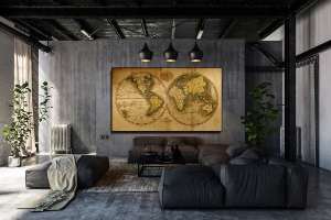
World Maps
Here you will find a large collection of woldmaps -starting as early as
16th century,and taking you forward all the way to todays more modern maps.

Country Maps
This is a very large collection consiting of mostly city maps from over 40 counrties.
Sorted by country you will find century old city maps that have been scanned and restored using original maps

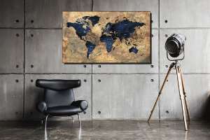
Speciality Maps
This is where you will come across unique and not so common maps along with our on in-house designs.
Using a combination of new and old can be very exiting and makes for a unique design when it comes to maps.
These are our own and are only available here.

Vintage
& Modern

Lorem ipsum dolor sit amet, consectetur adipiscing elit, sed do eiusmod tempor incididunt ut labore et dolore magna aliqua. Ut enim ad minim veniam, quis nostrud exercitation ullamco laboris nisi ut aliquip ex ea commodo consequat.

